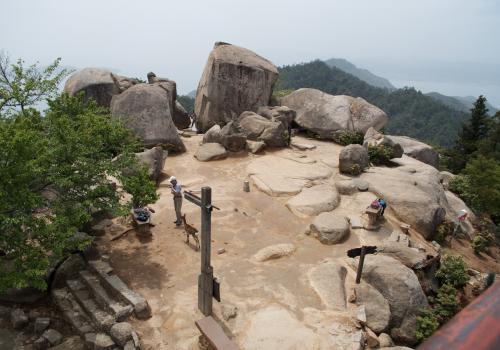
Mt. Misen
Mt. Misen is located behind Itsukushima Shrine on Miyajima. It rises from behind shrine at sea level to 529.8 meters. Its interesting geology, virgin forests and unique wildlife make it popular hiking destination. It takes over 90 minutes to hike from the town to the summit of Mount Misen.
There are three hiking trails: Daishoin course, Momijidani course and Omoto course. The one shown in on this webpage is the Daishoin course that leaves town on the west side of the Daishoin Temple complex.
Hatsukaichi City
Hiroshima Prefecture
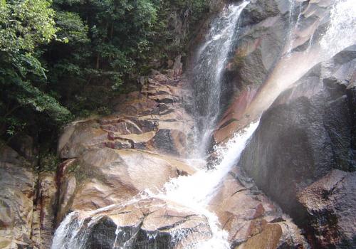
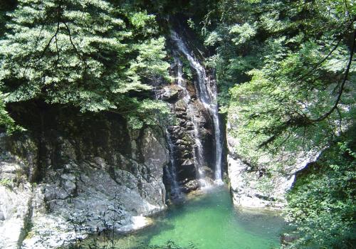
Ogashira Shrine and Imose Waterfalls
The waterfalls are located at a small shrine complex called Ogashira which is a brisk 20 minute walk from Ono-Ura train station. Part of its popularity is likely because of the fact the Sanyo expressway exits right in front of its doorstep.
Hatsukaichi City
Hiroshima Prefecture
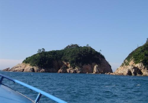
Okunoshima National Park
Okunoshima Island (大久野島) is a small resort and historical park with beautiful beaches and an incredible view of the inland sea from its summit. The entire island (0.7 km2 / 4.2 km circumference) is part of the Seto Inland Sea National Park. It is about a 20 minute ferry ride from Tadanoumi which is a town east of central Takehara City.
Takehara City
Hiroshima Prefecture
Omijima (Sea Alps)
Omijima (青海島 - Oumi Island) in Nagato City faces Korea across the Sea of Japan (East Sea) on the northern coast of Honshu in Yamaguchi Prefecture. The island's scenic outcroppings on the north coast are called the "Sea Alps" (海上アルプス). The name is quite suitable as the sharp stone columns thrusting out of the ocean and sheer cliffs with ocean caves are indeed reminiscent of the real alps. It all makes for a dramatic backdrop for wildlife and fishing boats.
Nagato City
Yamaguchi Prefecture
Sakurajima
Sakurajima (桜島), one of Japan's most active volcanos, is located in southern Kyushu. A symbol of the area, the 1117 meters volcano dominates the north-end of Kagoshima Bay. No trip to Kagoshima City, which is on the west side of the bay across from the volcano, is complete without watching Sakurajima send up another plume of fine ash in one of the minor eruptions that occur hundreds of times a year and then hopping on the ferry to get a closer look.
Kagoshima City
Kagoshima Prefecture
Sandankyo Valley
The major attraction that brings people to north west Hiroshima Prefecture after the snow has melted off Geihoku's ski resorts is a 16 km ravine called Sandankyo (三段峡). The Shibaki River which cascades down through the ravine over cliffs and down rapids is the source of the Ota river which flows through Hiroshima City. The area's beauty remained undiscovered and unknown to most people until around 1910 because of the sheer inaccessibility of the region.
Akiōta-chō
Hiroshima Prefecture
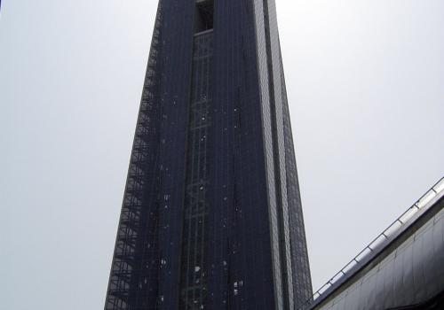
Shimonoseki Kaikyo Yume Tower
The Kaikyo Yume Tower was opened by
Yamaguchi Prefecture on July 20, 1996. At 153 meters, this landmark is visible from throughout the city. The tower is a bold addition to the skyline that enables visitors to get a birds-eye view from the observation floor. The view of the Kanmon Straits from 143 meters is well worth the price of admission.
Shimonoseki City
Yamaguchi Prefecture
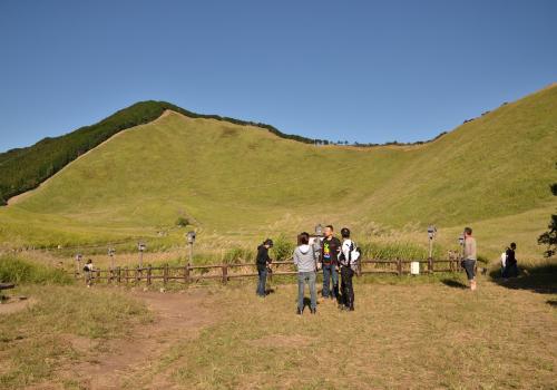
Soni Plateau
The Soni Plateau or Soni Kōgen (曽爾高原) is a marshy meadow filled mostly with a tall grass called susuki in Japanese. It is located in a remote part of northeast Nara Prefecture under the west facing slope of a roughly north-south line of mountain peaks that is the boundary with Mie Prefecture to the east. The plain itself is about 700 meters above sea level and covers 38 hectares. Closest to the plateau, Mount Kame (亀山) is 849 meters. Kame means turtle in Japanese and this mountain is thought to be shaped like one. The hiking trails around the plateau are popular in the Kansai region.
Soni-mura
Nara Prefecture
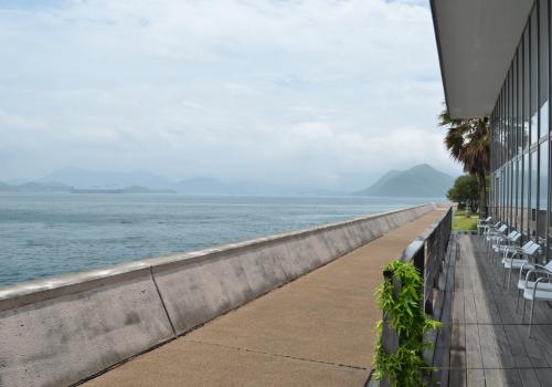
Sunami Beach Park
Sunami Beach Park is a large ocean recreation area which is nationally recognized for its design. In 2001, it received a Ministry of Land, Infrastructure and Transport's Award for its advancement of the local human experience. This "Barrier Free" (disability friendly) ocean park is located 20 minutes by bus west of Mihara City on the Seto Inland Sea.
Mihara City
Hiroshima Prefecture
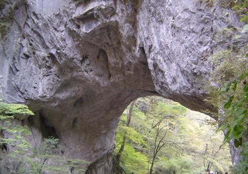
Taishakukyo Gorge
Taishakukyo (帝釈峡) in northeastern Hiroshima Prefecture near Shobara City covers a large area of scenic karst formations centered around Shinryu Lake. The area has been a designated place of scenic beauty since 1923. There are a numerous memorable views but its three most famous parts are Taishaku Valley, Onba Bridge and Shinryu Lake.
Shōbara City
Hiroshima Prefecture
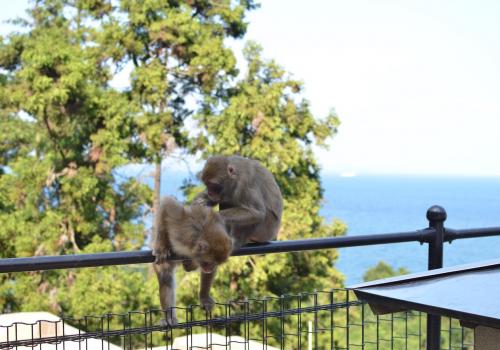
Takasakiyama Natural Zoological Garden
Takasakiyama Natural Zoological Garden is a monkey park near Beppu in Oita Prefecture. It is located across from Umitamago Aquarium. It is run like an open-air zoo exclusively for Japanese macaques (or snow monkeys). The monkeys roam freely. There are no cages or fences separating you from the cute baby monkeys clinging to their moms and the aggressive dominant males charging around.
Ōita City
Ōita Prefecture
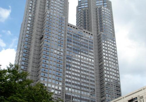
Tokyo Metropolitan Offices
Image does not exist: tokyo-metro-office-20060916-10-17-26.jpg
The two towers of the Tokyo Metropolitan Offices in Shinjuku both have observation floors that are open to the public. Each is a mirror image of the other and which you pick all depends on if you want to look north or south from the 45th floor. If you arrive on a day when one side is closed then you are saved from making that decision.
Pages
All rights reserved © 1999-2015 Matthew Bystedt